Golf courses can cover large expanses of land that may vary in geological properties. Understanding these geological properties is critical because these properties can pose risks for ground or surface water contamination.
Surficial Geology
Surficial geology is the study of landforms and the unconsolidated sediments that lie beneath these landforms. The type of surficial geology, along with the type of subsoil and depth to groundwater, can influence the surface water and groundwater interactions that allow contaminants to move from one medium to the other.
Soils with hard pans or finer textured horizons in the subsoil may have a greater ability to adsorb contaminants as they leach through the surface horizons. The greatest potential for groundwater contamination occurs where sandy soil overlies porous materials (such as limestone or coarse gravel) with a shallow water table.
For New York State maps of surficial geology, see http://www.nysm.nysed.gov/gis/#surf.
Karst Geology
Karst geology (also called karst topography) is a type of surficial geology associated with carbonate bedrock (limestone, dolomite, or marble) and characterized by sinkholes, depressions in the land surface, caves, and underground drainage systems.
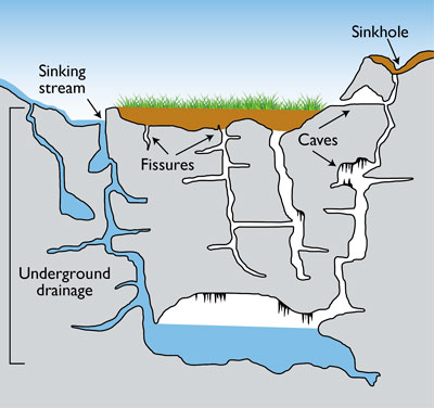 Karst geology is characterized by such features as sinkholes, fissures, and caves.
In New York State, continental glaciation and local stratigraphic and structural conditions have produced karst features, which may affect the quality and quantity of groundwater in the state.
Karst features are created over time by rainwater, which dissolves the carbonate bedrock as it drains into fractures, creating channels and openings in bedrock. These channels and openings to the ground surface provide a direct connection between surface water and groundwater; these enhanced connections are known as “focused” or ‘direct’ recharge. Direct recharge quickly replenishes the water supply; however, it also leaves the aquifer particularly vulnerable to contamination, especially where the topsoil layer is thin and does not filter out potential contaminants.
Available bedrock geology maps of NYS identify carbonate bedrock areas that indicate the potential presence of karst features. However, higher resolution maps of the boundaries as well as karst features in these bedrock units would be better suited for site-specific management, but may not be available from other sources.
For more information on karst geology, see:
- Bedrock geology map of NYS: http://www.agiweb.org/environment/karstmap.pdf
- “Living with Karst”, American Geological Institute: http://www.agiweb.org/environment/publications/karst.pdf
- Fickies, R.H. and Fallis, E., 1996, Rock Type Map of New York State: New York State Geological Survey, Open file Report 1g1222, scale 1:1,000,000.